LDP3's Nature Network
Welcome to our LDP3 Nature Network page 🌳 🦋🦇🌿🍄🟫
What is a ‘Nature Network’?
The primary purpose of a Nature Network is ecological connectivity. Nature Networks are best considered at a landscape scale to ensure species can move around freely between existing nature rich areas and irrespective of administrative boundaries. A Nature Network connects together nature-rich sites including restoration areas and other environmental projects, through a series of areas of suitable habitat, habitat corridors and stepping stones.
Why is a ‘Nature Network’ needed in East Ayrshire?
Although there is no statutory requirement to identify a ‘nature network’, doing so is important in order to be able to implement the requirements of National Planning Framework 4 (NPF4). Their identification is key to enable East Ayrshire to deliver against multiple policies, including Policy 1: Tackling the climate and nature crisis, Policy 2: Climate Mitigation and Adaption, Policy 3: Biodiversity and Policy 4: Natural Places. Policy 3 requires LDPs to ‘promote nature recovery and nature restoration across the development plan area, including by: facilitating the creation of nature networks and strengthening connections between them to support improved ecological connectivity.’
It is widely recognised that one of the main drivers of biodiversity loss is land-use change and resulting habitat fragmentation – resulting in large areas of habitat being broken and divided into smaller areas of habitat which are isolated from one another. It is well recognised that to tackle biodiversity decline action must be taken to increase the total amount of biodiversity-rich habitats protected or conserved and ensure they are better connected.
Nature Networks, and the future use of nature-based solutions, will significantly help to deliver greater climate change resilience and adaption for everyone, including nature. Nature Networks are one way to contribute to the Scottish Biodiversity Strategy’s vision:
“By 2045, Scotland will have restored and regenerated biodiversity across our land, freshwater and seas. Our natural environment, our habitats, ecosystems and species, will be diverse, thriving, resilient and adapting to climate change. Regenerated biodiversity will drive a sustainable economy and support thriving communities and people will play their part in the stewardship of nature for future generations.”
Nature Networks are a core policy outcome of National Planning Framework 4 (NPF4):
“LDPs should protect, conserve, restore and enhance biodiversity in line with the mitigation hierarchy. They should also promote nature recovery and nature restoration across the development plan area, including by: facilitating the creation of nature networks and strengthening connections between them to support improved ecological connectivity; restoring degraded habitats or creating new habitats; and incorporating measures to increase biodiversity, including populations of priority species.”
The primary purpose of a Nature Network is ecological connectivity. This connectivity is required for fully functioning and healthy ecosystems. Nature Networks will ensure that sites contributing to 30 by 30, and other important areas for biodiversity, are well-connected and so provide maximum benefits to biodiversity. Scotland’s Nature Network will underpin the resilience and health of species and habitats at a national, regional and local scale.
Nature networks (including green infrastructure within settlements) provide multiple benefits environmentally, but also socially. They promote health and healthier lifestyles by encouraging exercise and physical activity by providing quality green spaces for walking, cycling, sports and play, providing better opportunities for active travel and physical activity. Nature networks promote positive physical and mental wellbeing by providing access to nature and attractive green spaces and breathing spaces. Nature networks can also promote inclusion and social equity by creating spaces for socialising, interaction and events. Nature networks can create a sense of place and improve the overall quality of places. These positive health and wellbeing outcomes positively align with the Local Outcome Improvements Plan 2024-2027 which identifies shared priorities for East Ayrshire.
Developing a 'Nature Network' for East Ayrshire
East Ayrshire Council commenced some initial workings to build a picture of its Nature Network. This was completed in-house utilising AECOM’s / CivTech’s Nature Network Tool. This has been conducted to identify opportunity mapping for connections between 30x30 sites spatially in accordance with the requirements of NatureScot’s Practitioner’s Guide to Nature Networks and Nature Network Framework.
This is a long-term approach which will help to stop biodiversity loss across Scotland, while bringing additional benefits to our local communities, including: health, wellbeing alongside adaptability and resilience to a changing climate. The purpose of opportunity mapping:
“is not to dictate where the Nature Network will be, but to outline the options available, that can then be used as the basis for discussions with local communities, landowners and managers, and experts to decide where best the Nature Network can and should go, in line with local priorities for both climate and nature.”
The Council is anticipated to play a central role in the development and creation of a ‘Nature Network’ for East Ayrshire, and will play an important supporting role in delivering on the ground projects – both on land owned by the Council and privately owned land. A spatially defined Nature Networks offers scope for communities, landowners/managers, businesses and existing partnerships to identify opportunities to make a positive contribution toward Nature Network delivery. Project delivery will likely be achieved by groups made up of these stakeholders, with local leadership and coordination specific to that area. The Council will be expected to consider how the delivery of nature networks could be achieved on land which is Council owned.
Methodology
The diagram below represents the process and approach the Council adopted to create the first iteration of East Ayrshire’s spatial Nature Network using the AECOM Eco-uplift toolkit.
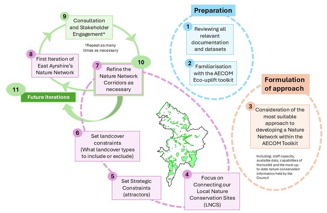
The Council reviewed all relevant documentation and datasets available and familiarised ourselves with the AECOM toolkit. Considering staff capacity, available data sets, the capabilities of the toolkit and what data we hold internally, we considered the most suitable approach to developing a nature network within the toolkit. It was determined that the most suitable approach was to concentrate on connecting up our Local Nature Conservation Sits as a means to further connect our 30 x 30 sites.
A thorough review of our LNCSs was completed recently as part of our LDP2 preparation to create our Local Nature Conservation Sites Non-Statutory Planning Guidance. As such, the Council know this to be the most update information in terms of habitats that are of value in East Ayrshire – particularly, given that our Local Biodiversity Action Plan is not up to date. To connect LNCSs the Council have selected points at the top of one LNCS and the furthest point on another (or at points where a watercourse enters the LNCS). Depending on presence and proximity, the following strategic constraints and features have been set as attractors within the toolkit in order to draw to corridor towards the given feature: Ancient Woodland Scottish Gardens and Designed Landscapes Attractor (high) Local Nature Conservation Site Attractor (mid) Special Areas of Conservation Attractor (highest) Sites of Special Scientific Interest Attractor (highest) Attractor (highest). Then utilising landcover data to determine what habitats are present and selecting the landcover options for inclusion/exclusion which are considered to most appropriate. The draft corridors were then refined as necessary - resulting in the first iteration draft nature network for East Ayrshire.
Embedding Nature Networks into LDP3
The Policy team are still at the very early stages in the production of LDP3. We anticipate to undertake a proposed plan consultation, which will include a spatially defined nature network in quarter 4 2027 into 2028. The Nature Network will be embedded within LDP3 as:
- A spatially defined and fixed map in the plan itself – which will be caveated that this will be amended and adapt over time as projects are completed on the ground. There will be an interactive live representation of the mapping through our Online Mapping Service.
- Set out within our Spatial Strategy
- Likely to have a specific nature network policy – which might be similar to our current CSGN policy
- It will also be cross referenced with other relevant policies within the LDP3 policy framework.


