The Ayrshire Roads Alliance has contributed to the development of a Local Flood Risk Management Plan (LFRMP) for Ayrshire in partnership with North Ayrshire Council, South Ayrshire Council the Scottish Environmental Protection Agency (SEPA) and Scottish Water. This is done on behalf East Ayrshire Council as part of the local authorities duties under the Flood Risk Management (Scotland) Act 2009.
The LFRMP for the Ayrshire Local Plan District describes how the actions set out in the Ayrshire Flood Risk Management Plan published by the Scottish Environment Protection Agency (SEPA) will be delivered.
One of the actions identified within the Ayrshire LFRMP for East Ayrshire is to undertake a flood study in Kilmarnock known to SEPA as Target Area 20.
Target Area 20 has been identified by SEPA as a Potentially Vulnerable Area (PVA) covering large parts of Kilmarnock. Potentially Vulnerable Areas are locations where flood risk is currently highest or is expected to increase in the future.
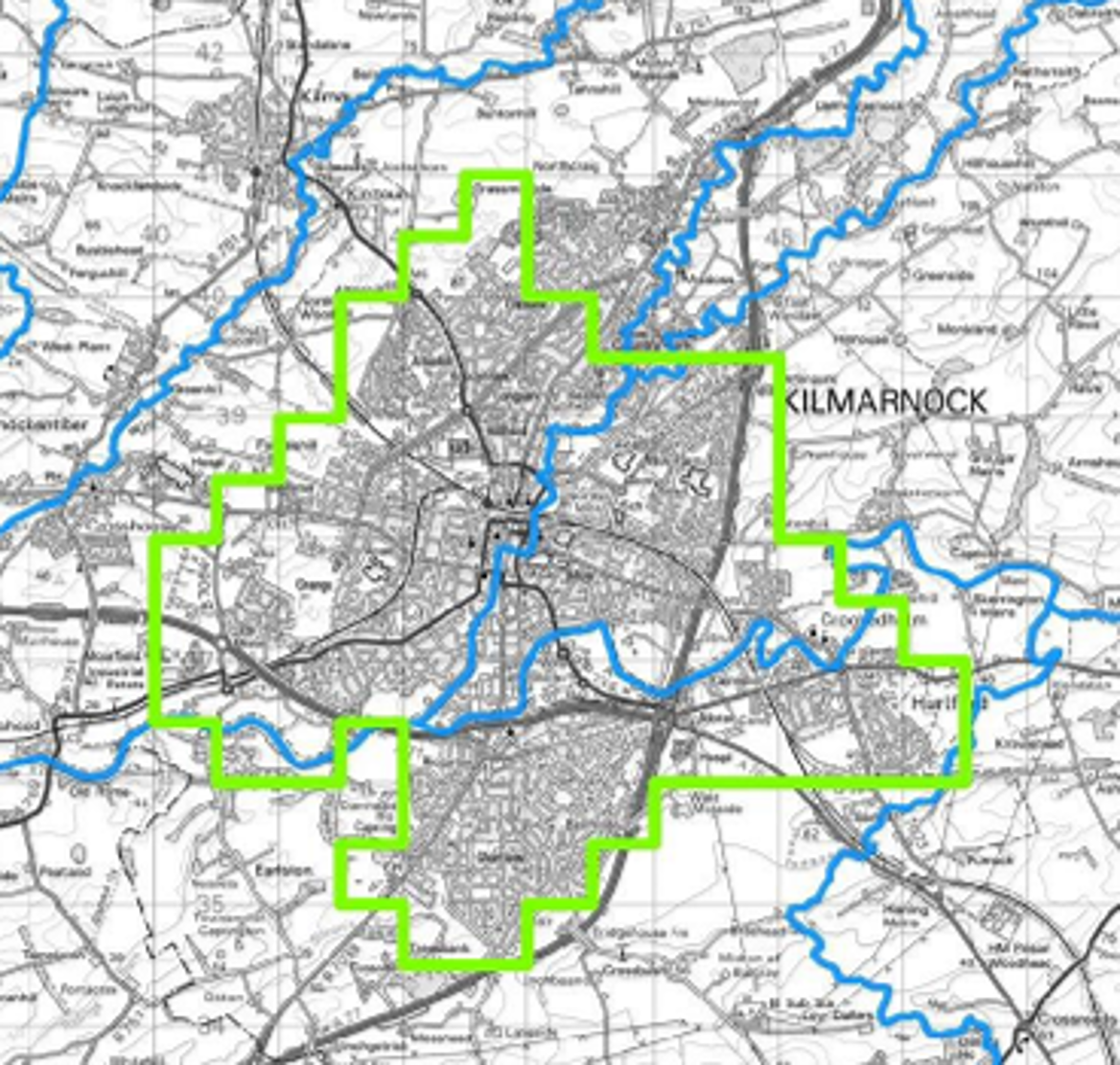
Around 3,800 people and approximately 2,400 homes and businesses within Target Area 20 are currently at risk from flooding, As climate change is expected to increase flood risk, the area vulnerable to flooding is projected to expand. By the 2080's, this is projected to increase the risk of flooding to around 4,900 people and 3,000 homes and businesses.
The purpose of the study is to identify areas at risk of flooding and assess a range of options to reduce that risk.The aim is to identify a preffered option that is technically, socially, environmentally and economically suitable, helping to reduce flood risk in Kilmarnock to an agreed standard of protection.
The preferred option will then be submitted to the Scottish Government for consideration for funding and potential implementation.
To understand flood risk, hydrological analysis and hydraulic modelling was carried out using the latest data from river modelling and surveys. This enabled detailed flood modelling of the River Irvine, Kilmarnock Water and any associated tributaries, identifying areas that could be at risk of flooding during different rainfall events.
The draft flood inundation maps for Target Area 20 have been produced for the following rainfall events, helping us understand how flood extents change as rainfall becomes more severe:
- 1 in 5 year rainfall event (20% annual chance)
- 1 in 10 year rainfall event (10% annual chance)
- 1 in 20 year rainfall event (5% annual chance)
- 1 in 50 year rainfall event (2% annual chance)
A 1 in 5 year event represents a flood that has a 20% chance of occurring in any given year, while a 1 in 50 year rainfall event has a 2% chance in any given year. These events do not occur on a fixed schedule and could happen more than once in the same year.
As part of this study, the Ayrshire Roads Alliance is carrying out a public consultation to gather feedback on the draft flood maps. We would like to hear from residents, businesses, community groups and other interested parties, particularly if you have knowledge or experience of previous flooding in the area.
Your feedback will help us assess the accuracy of the draft flood maps and improve our understanding of flood risk in Target Area 20
As part of the process Ayrshire Roads Alliance are carrying out a consultation exercise to gain feedback on the draft inundation mapping from residents, community groups and any other parties who can provide an insight to previous flooding that they have experienced.
The Ayrshire Roads Alliance has contributed to the development of a Local Flood Risk Management Plan (LFRMP) for Ayrshire in partnership with North Ayrshire Council, South Ayrshire Council the Scottish Environmental Protection Agency (SEPA) and Scottish Water. This is done on behalf East Ayrshire Council as part of the local authorities duties under the Flood Risk Management (Scotland) Act 2009.
The LFRMP for the Ayrshire Local Plan District describes how the actions set out in the Ayrshire Flood Risk Management Plan published by the Scottish Environment Protection Agency (SEPA) will be delivered.
One of the actions identified within the Ayrshire LFRMP for East Ayrshire is to undertake a flood study in Kilmarnock known to SEPA as Target Area 20.
Target Area 20 has been identified by SEPA as a Potentially Vulnerable Area (PVA) covering large parts of Kilmarnock. Potentially Vulnerable Areas are locations where flood risk is currently highest or is expected to increase in the future.
Around 3,800 people and approximately 2,400 homes and businesses within Target Area 20 are currently at risk from flooding, As climate change is expected to increase flood risk, the area vulnerable to flooding is projected to expand. By the 2080's, this is projected to increase the risk of flooding to around 4,900 people and 3,000 homes and businesses.
The purpose of the study is to identify areas at risk of flooding and assess a range of options to reduce that risk.The aim is to identify a preffered option that is technically, socially, environmentally and economically suitable, helping to reduce flood risk in Kilmarnock to an agreed standard of protection.
The preferred option will then be submitted to the Scottish Government for consideration for funding and potential implementation.
To understand flood risk, hydrological analysis and hydraulic modelling was carried out using the latest data from river modelling and surveys. This enabled detailed flood modelling of the River Irvine, Kilmarnock Water and any associated tributaries, identifying areas that could be at risk of flooding during different rainfall events.
The draft flood inundation maps for Target Area 20 have been produced for the following rainfall events, helping us understand how flood extents change as rainfall becomes more severe:
- 1 in 5 year rainfall event (20% annual chance)
- 1 in 10 year rainfall event (10% annual chance)
- 1 in 20 year rainfall event (5% annual chance)
- 1 in 50 year rainfall event (2% annual chance)
A 1 in 5 year event represents a flood that has a 20% chance of occurring in any given year, while a 1 in 50 year rainfall event has a 2% chance in any given year. These events do not occur on a fixed schedule and could happen more than once in the same year.
As part of this study, the Ayrshire Roads Alliance is carrying out a public consultation to gather feedback on the draft flood maps. We would like to hear from residents, businesses, community groups and other interested parties, particularly if you have knowledge or experience of previous flooding in the area.
Your feedback will help us assess the accuracy of the draft flood maps and improve our understanding of flood risk in Target Area 20
As part of the process Ayrshire Roads Alliance are carrying out a consultation exercise to gain feedback on the draft inundation mapping from residents, community groups and any other parties who can provide an insight to previous flooding that they have experienced.

Thank you for your contribution!
Help us reach out to more people in the community
Share this with family and friends